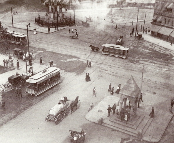
Michigan-Detroit-Street Railways:Broadway & Jefferson: 1890

Jefferson Avenue was named for President Thomas Jefferson, who appointed the first Michigan territorial officials and was a good friend of Augustus Woodward. It was first surveyed in 1807 and named "Main Street," but soon renamed for Jefferson. At its intersection with Griswold it passes through the heart of the old cemetery of St. Anne's Church where the remains of Detroit's earliest inhabitants are buried.
Waterways of Detroit
The waterways surrounding Detroit carry the lifeblood of the city and are the foundation of its establishment. Lake St. Claire, the Detroit River, and Lake Erie, frame the city in a network of natural boundaries.
1890 Detroit:
Since the 1790s, Detroit has represented the boundary between nations. In its days as a French Military outpost, the French to protect their interests in America.
Detroit Balances on the United States-Canada border.
Detroit-Ann Arbor-Flint
Detroit-Windsor, Canada
Dearborn, MI=Ford Motor Company
Suburbs: Royal Oak, Southfield, Allen Park, Livonia, Warren,
Early 1800's Detroit at a Glance
By 1751, the Port of Detroit had a French population of six hundred, and it was an important fur-trading center. When dredging created navigational channels between the Great Lakes and the Hudson River and the Erie Canal opened in the early 1800s, the Port of Detroit became an important passageway to the promising Northwest Territory.
In the early 1800s, Detroit is just starting to gain her footing as a city, experiencing monumental growth after being proclaimed the Territorial Capital of Michigan Territory. Commerce along the Detroit River establishes Detroit as the trade center for the area, The Port of Detroit was the capital of Michigan from 1805 to 1847. Falling to British troops during the War of 1812, the United States recaptured the city in 1813 and incorporated it in 1815. Before the American Civil War, its proximity to the Canadian border made the Port of Detroit an important stop on the Underground Railroad. Lieutenant Ulysses S. Grant was stationed in the city at the time, and his home still stands on the Michigan State Fairgrounds.
In the early 1800s, Detroit is just starting to gain her footing as a city, experiencing monumental growth after being proclaimed the Territorial Capital of Michigan Territory. Commerce along the Detroit River establishes Detroit as the trade center for the area, The Port of Detroit was the capital of Michigan from 1805 to 1847. Falling to British troops during the War of 1812, the United States recaptured the city in 1813 and incorporated it in 1815. Before the American Civil War, its proximity to the Canadian border made the Port of Detroit an important stop on the Underground Railroad. Lieutenant Ulysses S. Grant was stationed in the city at the time, and his home still stands on the Michigan State Fairgrounds.
The Detroit Railroads
1863 - Horse-drawn trolleys begin service on Jefferson Avenue.
1880's -Electric streetcar service begins in Windsor.
1892 - Electrification spreads to Detroit, replacing horse-drawn railcars. Interurban trolley service from Detroit begins to grow, helping to create and serve several suburban areas in coming years.
1901 - A Cleveland syndicate consolidates several independent interurban operations under one entity-Detroit United Railway (DUR). See MAP of the DUR system at its zenith.
1919-1920 - The Detroit Rapid Transit Commission prepares the first regional transportation plan, recommending a multi-modal system. Mayor James Couzens vetoes a bond issue to create a subway system.
1922 - The City takes over streetcar operations. Detroit now has the largest municipally owned transit system in the country: the Department of Street Railways (DSR).
Gilded Age Detroit at a Glance: http://fermi.jhuapl.edu/states/1895/mi_1895.jpg
Called the “Paris of the West,” the Port of Detroit held many mansions and buildings in the Gilded Age of the late 1800s. Its strategic location on the Great Lakes made it an important transportation hub for the Nation. Growing steadily from the 1830s, it was home to industries engaged in shipping, shipbuilding, and manufacturing.
The River separates the British province of Ontario, formerly Upper Canada, with the State of Michigan, County of Wayne. The city is bounded on the North by the townships of Greenfield and Hamtramck, on the east by Hamtramck, and on the west by the township of Springwells. The townships of Leeville and Norris are also within the limits of the city, about six miles
At this time in history, the suburb Grosse Pointe on the shores of Lake Saint Claire has evolved into a relaxation and resort spot for vacationing cityfolk, and one of the most desirable suburbs of Detroit.
The suburb of Greenfield borders the city on the North, and is the location of the enormous seed farm of D.M. Ferry and Company--a farm of about three hundred acres.
At this time, Detroit had gained its name as the "Paris of the Midwest." And if Detroit was Paris, the Detroit River was the Seine.
Detroit River Declared a Public Highway by Act of Congress on October 19th, 1819
Railroad Ferry Boats, 1854
There are a number of islands around Detroit, two of them above, and twenty below the city. Belle Isle was an island designated as a City Park, Peach island is located at the head of the River,
The islands below the city are named Fighting, Mud, Grassy, Grass, Mama-Juda, Grosse, Turkey, Stoney, Slocum's, Humbug, Fox, Elba, Calf, Snake Hickory, Sugar, Bois Blane, Horse, Cherry, and Tawa or Celeron.
Downtown Detroit streetcars