Structural Influences
Detroit acquired her current road system from three distinct periods in her history. Most of the French rectilinear influences on the city were removed with the fire of 1805. Depicted on the maps below, the plan of Judge Augustus B. Woodward was to revitalize Detroit by implimenting a "wheel-and-spoke" design that echoed the layout of Washington D.C. Two pictures are shown below for comparison:
The wheel and spoke design was widely unpopular with the French citizens of Detroit, and only one "spoke" was ever established in central downtown. The area south of Michigan Avenue marks the site of the old Fort Detroit built in 1760 by the British, after being renamed Fort Shelby, it was decomissioned in the mid-1800s. Instead of continuing the new "wheel-and-spokes" layout into the continuation of the city, architects incorporated the old French grid-style road system into the New City.
This French "grid-style" stemmed from old ribbon farms that had previously encompassed the land of Detroit. Extending outward from the city, roads followed both the old boundaries of the ribbon farms and the new radial roads of Woodward's design.
*Native American influences are evident in the physical layout of the city. Michigan Ave.-- aka U.S. 12, Chicago Road, Sauk Trail -- follows an old Native American trail used for trading to circumnavigate around the south shore of Lake Michigan.
Detroit Ribbon Farms-1796

The name ribbonfarm refers to the ribbon farms of 18th century Detroit — strips of lands 2-3 miles long, each with 2-300 yards along the Detroit river waterfront. This kind of structure allowed farmers easy access to the river without having to leave their land. During this time, the River was the lifeblood of the Detroit settlement and allowed for easy transportation of goods and people between outposts in the Northwest.
Prior to 1805, most of Detroit was settled in the style of French Ribbon Farms. This created complications when property owners deeded their plots to the city when it was rebuilt in 1805. Different property owners decided where they were going to place the secondary east-west streets, while the north-south streets leading away from the river followed the property lines of the ribbon farms.
Prior to 1805, most of Detroit was settled in the style of French Ribbon Farms. This created complications when property owners deeded their plots to the city when it was rebuilt in 1805. Different property owners decided where they were going to place the secondary east-west streets, while the north-south streets leading away from the river followed the property lines of the ribbon farms.
Plan Du Fort Du Detroit
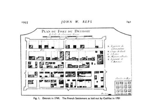
This map dates from 1749 when Detroit was still occupied by the French.
Detroit at the turn of the 19th century

Detroit expanded greatly under British Rule. It was fortified and extended to include other settlements in the surrounding areas. This map depicts the way Detroit looked the year it was given to the United States under the provisions of Jay's Treaty in 1796.
At this point in history, the city's contour resembles a shooting star extending outwards from a central fortified point. The limits of the "city" are defined by the Detroit River and fortified. The outer extensions of the city display a geometric layout typical of settlements during this time, allowing for easy access to the Detroit River and navigation of streets.
The influence of Detroit on the surrounding area as a frontier trading center along the Detroit leads government leaders to establish it as the Seat of Michigan Territory in 1802. Detroit showed a lot of potential, until it was consumed in a devastating fire on June 11th, 1805.
Fire of 1805 and Reconstruction Afterward

While the Detroit fire was a devastating event for the fledgling town, it was not an uncommon for fires of this magnitude to decimate cities in the 17 and 1800's due to wood construction and primitive fire-fighting technology. What makes the Detroit fire of 1805 memorable was the reconstruction and reform that took place after the fire.
Augustus B. Woodward Plan: 1807

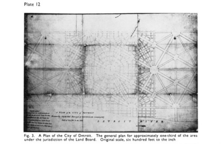
The fire of 1805 opened the window for a change in government, and an opportunity for rebirth in the design of the Detroit Community. Michigan Territory Judge Augustus B. Woodward was appointed to plan the new layout of the city. His design was not fully implemented, but characteristics of it are still visible today. Detroit's layout is similar to that of Washington D.C.'s, but fundamentally different. Washington has two layouts superimposed on one another; a classic grid system with right-angle intersections overlaid with large diagonal avenues that connect major crtical points of the city. Detroit, instead of utilizing the block system, is divided into triangles (see Triangular Block figure below). In this way, many of the traffic problems that Washington faced were eliminated in Detroit. City Planners implemented two major types of urban space: the campus, and the circus. Note the two most famous examples in the map to the right: The Campus Martius, and the Grand Circus. Both features are still visible in maps of Detroit today. The streets and boulevards of the city stretch out from the central Grand Circus like veins and arteries from a heart. Grand avenues and boulevards extended into smaller side streets and roads that tapered into an intricate system of alleyways that effectively linked the various realms of the city.
Augustus B. Woodward Plan for Detroit
|
Pierre L'Enfant's Plan for Washington D.C.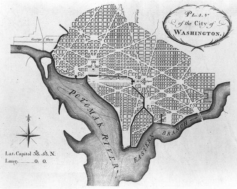
|
The Triangular Street System and Urban
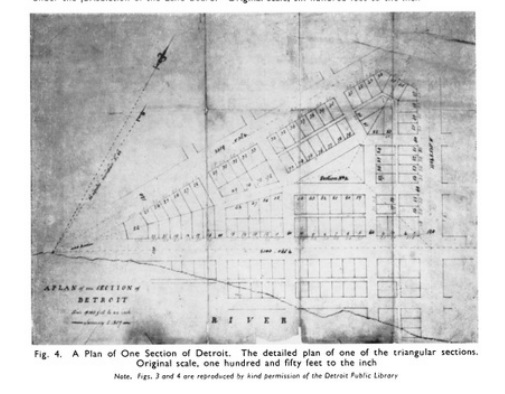
Notice the Land Subdivision Pattern:
"The 'perpendicular lines' divided each equilateral triangle into six right-angle triangles. Each of these was to be known as a 'section.'"(Reps 244)
The central part of each triangular section was to be left open. An Act of the Governors and Judges in 1807 makes the reason clear:
"...the internal space of ground, in the middle of every section, shall be reserved for public wells and pumps, for markets, for public schools, for houses for the reception of engines or other articles for the extinction of fires, and the preservation of the property of the inhabitants for houses for the meeting of religious, moral, literary, or political societies, or other useful associations, and generally, for such purposes of utility or ornament, as the city council of Detroit may, at any time by law, provide; or as, otherwise, the inclination and taste of the proprietors of the lots in such section, or that of the major part of them, may direct; and in the same manner shall be paved, gravelled, planted with trees, or otherwise improved and ornamented."(Reps 246-247)
"Hub and Spoke" Design
Drawing from L'Enfant's plan of Washington D.C., the idea was that as the city grew, more hexagonal road systems would be established, creating grand circuses at their intersection points. As Detroit grew ever larger, this plan was abandoned and the city was overlaid by the grid system.


Current Map of Detroit

A current image of Detroit. The original "spokes" layout is in the lower half of the picture next to the Detroit River with the spokes coming from the Grand Circus toward the water.
1830/Modern Overlay

Here, you can still see the similarities between the original plans for the city, and its layout today.
Overlay of 1873 Map

The contour of the railroad track, michigan avenue, and other main arteries line up well with the 1873 map.
